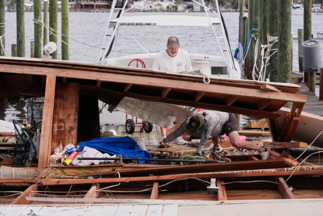
Updated October 11, 2026. The aftermath of Hurricane Isaias has left communities along Florida's Emerald Coast assessing storm damage, restoring electricity and checking coastal access after the hurricane made landfall near Destin on Friday, October 9. Seaside, Florida, and neighboring communities along Scenic Highway 30A in South Walton County experienced the effects of a powerful Category 2 hurricane that brought damaging winds, heavy rainfall and dangerous coastal conditions to the Florida Panhandle.
Although Isaias weakened rapidly after moving inland, the storm left extensive utility disruptions across the region. Residents and property owners around Seaside, Santa Rosa Beach, WaterColor and Grayton Beach have been concerned about electricity, flooding, damaged roads and the condition of beach accesses.
As of October 11, detailed public damage assessments for individual Seaside properties and beach boardwalks remained limited. Some residents reported improving conditions, while others described localized outages and standing water. These firsthand reports are useful indicators of conditions but should not be treated as comprehensive official assessments.
Hurricane Isaias Aftermath: Latest Confirmed Updates
| Category | Latest Verified Information |
|---|---|
| Hurricane landfall | October 9, 2026, near Destin, Florida |
| Intensity at landfall | Category 2, with sustained winds of 105 mph |
| Storm status | Weakened to a post-tropical cyclone on October 10 |
| Reported fatalities | At least four across Florida and Alabama |
| Peak regional outages | Nearly 900,000 customers affected across several states |
| Florida power outages | 439,162 accounts without service at 1 p.m. October 10 |
| Seaside property damage | Comprehensive town-specific assessment not yet verified |
| 30A beach access | Individual access-point conditions require local confirmation |
| Recovery priorities | Electricity, debris removal, floodwater drainage and infrastructure inspections |
The Florida statewide outage figure comes from the governor's October 10 recovery briefing. It should not be interpreted as the number of outages in Seaside or Walton County alone.
What Happened When Hurricane Isaias Hit the Florida Panhandle?
Isaias intensified over the Gulf of Mexico before reaching the northern Gulf Coast. The hurricane had attained Category 3 strength offshore but weakened before crossing the coast near Destin.
According to Florida officials, the storm made landfall at approximately 9:30 p.m. Eastern Daylight Time on October 9 with maximum sustained winds of 105 mph.
Wind gusts reached 116 mph near Santa Rosa Sound and 100 mph near Pensacola. At Panama City Beach, a water-level gauge recorded coastal water approximately 5.6 feet above the average high tide level.
These observations demonstrate the intensity of Isaias across the wider Panhandle, although they do not establish identical wind speeds or water levels in Seaside.
After landfall, the storm traveled through the western Florida Panhandle into southern Alabama, where it weakened into a post-tropical cyclone early Saturday.
The reduction in wind intensity allowed recovery operations to begin, but debris, power failures and floodwater continued to create hazards.
Seaside Florida Hurricane Update: What Is Known About Local Damage?
Seaside is a planned coastal community along Scenic Highway 30A in Walton County, east of Grayton Beach and near WaterColor. Its beachfront setting, pedestrian-oriented streets, vacation homes and public gathering spaces make coastal access and infrastructure conditions particularly important after severe weather.
Hurricane Isaias made landfall west of Seaside, placing South Walton within the broader area affected by the hurricane's circulation.
Walton County officials convened a special meeting on October 8 to address storm preparations, evacuations and government office closures.
After landfall, local residents began sharing reports about electricity, standing water and property conditions along the 30A corridor.
However, the reports reviewed through October 11 did not establish a verified count of destroyed homes, damaged commercial buildings or unusable boardwalks within Seaside itself.
It would therefore be premature to characterize Seaside as either devastated or completely unaffected.
Were Homes and Businesses in Seaside Damaged?
Confirmed regional reporting documents damaged roofs, fallen trees and structural destruction in parts of the Florida Panhandle, including communities near the landfall area.
Those regional observations do not automatically establish equivalent damage in every South Walton neighborhood.
Homeowners and businesses in Seaside should evaluate individual buildings for roof damage, water intrusion, broken exterior fixtures and electrical hazards before resuming normal occupancy.
Commercial reopening may also depend on power availability, water service, staff access and building safety inspections.
Hurricane Isaias Power Outages in Seaside and Santa Rosa Beach
Electricity restoration is one of the most immediate concerns along Scenic Highway 30A.
In an October 10 online discussion among 30A residents and visitors, one commenter reported that family members near Eastern Lake, east of Seaside, had lost electricity on Friday evening.
The same discussion included concerns that standing water was delaying utility repairs in some neighborhoods.
By October 11, another participant reported that electricity had returned to part of Blue Mountain Beach.
These reports describe specific households and neighborhoods. They do not establish that power had been restored throughout Blue Mountain Beach, Seaside or the wider 30A corridor.
How Many Customers Were Without Power?
Across Florida, Governor Ron DeSantis reported 439,162 electricity accounts without power as of 1 p.m. on October 10.
Broader reporting placed the initial number of outages across multiple southeastern states near 900,000, with the total declining as utility companies restored service.
Florida deployed thousands of utility personnel and emergency workers to support restoration efforts.
The precise number of customers still without power in Seaside on October 11 was not established in the verified information available for this article.
Why Can Electricity Restoration Take Several Days?
Hurricane recovery often requires more than reconnecting damaged wires.
Crews may first need to remove fallen trees, inspect substations, replace utility poles and confirm that flooded electrical equipment can be safely operated.
Flooded access roads can also delay repairs.
Restoration times vary by neighborhood, especially when damage affects smaller distribution lines serving individual streets.
Residents should treat utility restoration estimates as provisional until the provider confirms service for their particular address.
Are Seaside Florida Beaches Open After Hurricane Isaias?
As of October 11, a comprehensive, verified list confirming the operating status of every Seaside and South Walton beach access was not available in the sources reviewed.
Beach conditions can vary substantially over short distances following a hurricane.
A public beach may appear accessible while individual stairs, boardwalks or dune crossings remain damaged or restricted.
Visitors should confirm the status of their intended access point before traveling.
Potential Beach Hazards After the Storm
Post-hurricane conditions may include:
- Unstable dunes and erosion near beach access points.
- Damaged wooden stairs, railings and boardwalks.
- Debris deposited by elevated water and strong winds.
- Strong rip currents and hazardous surf.
- Standing water or contaminated runoff near low-lying areas.
- Temporary restrictions for debris removal and inspections.
These are recognized hazards associated with hurricane aftermaths. They are not a confirmed inventory of damage specifically found at Seaside Beach.
How Were Grayton Beach, WaterColor and Blue Mountain Beach Affected?
Communities near Seaside experienced the same broader weather system, but available observations did not provide equivalent damage assessments for every location.
Grayton Beach
Grayton Beach is located west of Seaside and includes coastal neighborhoods, natural areas and access to Grayton Beach State Park.
Following the hurricane, the relevant concerns include road access, downed trees, floodwater and beach infrastructure.
No comprehensive post-storm damage total specifically for Grayton Beach was confirmed in the reporting reviewed.
WaterColor
WaterColor lies immediately west of Seaside and contains vacation accommodations, homes and beach facilities.
Online discussions after landfall included residents seeking information about homes and boardwalk conditions near WaterColor.
Those requests demonstrate local concern but do not independently verify that particular boardwalks were destroyed or closed.
Blue Mountain Beach
Blue Mountain Beach residents shared mixed reports during the first two days after the storm.
One October 11 account indicated that electricity had returned to a location in the neighborhood.
Conditions elsewhere could differ because neighborhood power restoration depends on the specific electrical infrastructure serving each area.
Eastern Lake and Santa Rosa Beach
Reports from the Eastern Lake area described outages and standing water following the storm.
These conditions were consistent with wider hurricane impacts across the Panhandle, although the extent of property damage and the duration of individual outages were not independently established.
Was Scenic Highway 30A Closed After the Hurricane?
Hurricane Isaias caused hazardous roadway conditions across the Florida Panhandle. State authorities deployed crews to remove trees and other obstructions and assist emergency vehicles.
The Florida Highway Patrol also provided traffic control along portions of U.S. Highway 98 affected by severe flooding.
However, the available official updates did not establish a continuous closure of the entire Scenic Highway 30A corridor.
Drivers should not assume that because a principal highway is open, every neighborhood road, bridge approach or beach access is usable.
Traffic signals may also remain inoperable in areas experiencing utility interruptions.
Florida's Emergency Recovery Response
Governor Ron DeSantis declared a state of emergency covering 27 Florida counties and visited the Destin area on October 10 to review response operations.
The state activated substantial emergency resources, including National Guard personnel, aviation assets and specialized teams trained for flooding and debris clearance.
National Guard and Emergency Personnel
Florida officials reported approximately 5,000 National Guard soldiers and airmen activated or staged in impacted areas.
Nearly 400 Florida State Guard personnel were also deployed to assist with recovery tasks.
Operations included search and rescue, clearing roads, supporting supply distribution, damage assessment and emergency transportation.
Emergency teams also used boats, high-water vehicles and drones to assess locations that could not be reached safely by conventional road transport.
Health Facilities and Vulnerable Residents
Florida's October 10 report recorded seven health-facility evacuations affecting assisted living facilities, a nursing home, a hospital and another care facility.
Sixty-nine providers reported power issues, and 27 providers reported damage.
The state also maintained special-needs shelters in affected counties, including Walton County.
These figures apply to the broader emergency response area rather than Seaside alone.
How Severe Was Hurricane Isaias Compared With Expectations?
Before landfall, forecasters warned of life-threatening coastal flooding, destructive winds and substantial rainfall along portions of the northern Gulf Coast.
Isaias had reached Category 3 intensity offshore, but its winds decreased before the storm crossed the coastline.
The hurricane still arrived as a powerful Category 2 system with sustained winds of 105 mph.
Some coastal areas reported less extensive structural damage than initially feared, while others sustained substantial losses.
This uneven pattern is typical of hurricane impacts, which depend on storm track, local exposure, construction quality, elevation and drainage conditions.
A reduction in maximum wind speed before landfall does not eliminate the risks from surge, flooding and fallen trees.
Hurricane Isaias Death Toll and Regional Damage
At least four people were reported killed across Florida and Alabama by October 10.
The fatal incidents included falling trees and carbon monoxide poisoning associated with generator use.
Damage was documented in parts of Pensacola, Panama City Beach and other Panhandle communities.
Associated Press reporting showed damaged building facades, torn roofs and debris left behind by the storm.
A comprehensive economic loss estimate for Hurricane Isaias had not yet been established in the reviewed reporting.
Likewise, the regional fatality count should not be misinterpreted as a death toll specifically for Seaside or Walton County.
Is It Safe to Visit Seaside Florida After Hurricane Isaias?
Travel decisions should be based on verified conditions at the specific destination rather than regional reports alone.
As of October 11, the available evidence was insufficient to confirm that all Seaside accommodations, restaurants, beaches and roads had returned to normal operations.
Before arriving, visitors should confirm their accommodation's electricity, water, access conditions and check-in availability.
They should also review current county emergency notices and beach safety information.
What Vacation Rental Guests Should Check
- Whether electricity and air conditioning are functioning at the property.
- Whether the building experienced flooding or roof damage.
- Whether drinking water and wastewater services are operating normally.
- Whether the intended beach access and parking areas are usable.
- Whether local road restrictions affect check-in or departure.
- Whether the rental operator has issued a storm-related cancellation or rebooking policy.
These checks are especially important for travelers arriving shortly after landfall because local conditions can change significantly during restoration work.
How Long Will Seaside Florida Take to Recover?
There is no verified single recovery timeline for Seaside as of October 11, 2026.
Minor debris cleanup and isolated utility repairs may progress relatively quickly, while more extensive electrical, structural or coastal infrastructure damage can require longer inspections and repairs.
The recovery of a vacation property also depends on factors such as insurance assessments, contractor availability and the extent of any water intrusion.
For that reason, recovery time estimates should be attached to particular services or locations rather than applied to the entire town.
Hurricane Safety During the Recovery Period
Even after a hurricane has moved inland, damaged infrastructure can present serious risks.
Residents returning to affected properties should use caution around fallen trees, damaged electrical equipment and floodwater.
Portable generators should operate outdoors, away from windows, doors and ventilation openings, because carbon monoxide can accumulate rapidly in enclosed areas.
People should also avoid driving through standing or moving floodwater and should follow official instructions concerning drinking water safety.
Unstable beach dunes and damaged access structures should not be crossed simply because the oceanfront appears calm.
Frequently Asked Questions
Did Hurricane Isaias hit Seaside, Florida?
Seaside was within the broader Florida Panhandle region affected by Hurricane Isaias. The hurricane's center made landfall near Destin, west of Seaside, on October 9, 2026.
How much damage did Seaside Florida receive?
The exact town-specific damage total had not been established in the public reports reviewed through October 11. Regional reporting confirms hurricane damage across the Panhandle, but the condition of individual Seaside properties requires local verification.
Is power restored in Seaside Florida?
A complete verified restoration status for all of Seaside was not available. Residents of nearby 30A communities reported both continuing outages and restored service at particular addresses on October 10–11.
Is Scenic Highway 30A open?
There was no verified complete status report for every segment of Highway 30A in the sources reviewed. Travelers should check current local traffic advisories before driving.
Are Seaside beaches open after Isaias?
A comprehensive list of open beach access points was not confirmed. Visitors should verify their intended access because post-storm inspections, surf hazards and infrastructure damage may affect individual locations.
What category was Hurricane Isaias when it hit Florida?
Isaias made landfall as a Category 2 hurricane with maximum sustained winds of 105 mph.
How many people died in Hurricane Isaias?
At least four deaths were reported in Florida and Alabama in the initial aftermath.
Is Hurricane Isaias still active?
It weakened to a post-tropical cyclone after moving inland on October 10. Its remaining moisture continued to pose rainfall and flooding risks elsewhere in the Southeast.
Conclusion
The aftermath of Hurricane Isaias has left Seaside and the surrounding 30A region facing the practical challenges of hurricane recovery after the storm struck the Florida Panhandle on October 9, 2026.
Confirmed regional impacts include widespread power outages, damaged buildings, blocked roads and at least four deaths across Florida and Alabama. Florida's emergency response involves thousands of personnel working on infrastructure restoration, debris removal and damage assessments.
For Seaside itself, the available evidence remains more limited. Some nearby residents have reported improvements in electrical service, but a complete public assessment of Seaside's homes, beach structures and commercial operations was not yet available as of October 11.
Residents, property owners and visitors should therefore rely on updated location-specific information when evaluating safety, travel plans and the progress of recovery along Florida's Scenic Highway 30A.
- Log in to post comments